| s/y Nine of Cups Utah...Crossroads of the West July 2010 |
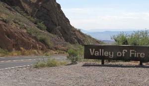
| The plan was to head from Las Vegas directly to St. George, Utah near Zion National Park for our first night. We barely made it out of Las Vegas when we saw the sign for Valley of Fire State Park in the Muddy Mountains...still in Nevada. It was too appealing to pass up so we stopped for a few hours. |
| Utah Facts... Capital: Salt Lake City Area: 84,900 sq mi (11th largest in the US) Population: ~2.3 million High Point: King's Peak, Uinta Mtns(13,528') Low Point: Beaver Dam Wash (2,350') State Nickname: Beehive State State Flower: Sego lily State Bird: California gull Utah became a state on January 4, 1896, making it the 45th state in the USA. On average, Utah's peaks are the tallest in the USA with an average elevation of 11,222 '. Famous Utahans include Brigham Young, historic leader of the Mormon religion, J. Moses Browning, inventor of Browning rifle and the legendary outlaw, Butch Cassidy. |
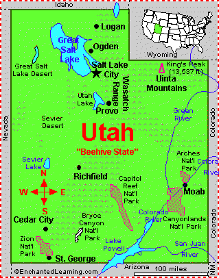
| Utah's Great Salt Lake, located in the northern part of the state, is the largest salt lake in the western hemisphere |
| The nickname Beehive State was chosen because Utahans relate the beehive symbol to industry and the pioneer virtues of thrift and perseverance. |
| The name Utah is derived from the Native American Ute tribe who lived in this area and means "people of the mountains". |
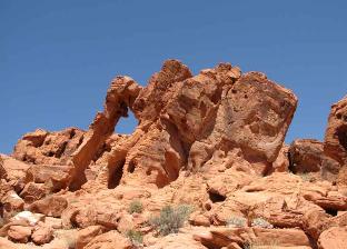
| Valley of Fire Goes Hollywood... From a sign in the park, we learned that several movies and hundreds of commercials have been filmed in the park including: The Good Son, 1,000,000 Years B.C., Stephen King's The Stand, The Professionals and Star Trek - Generations. |
Created in 1935, Valley of Fire is Nevada's
oldest and largest state park.
oldest and largest state park.
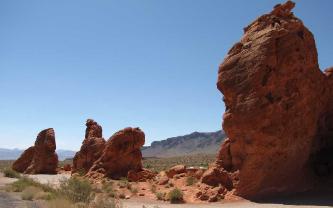
Views from the road which meanders
through the park were wonderful.
through the park were wonderful.
| Valley of Fire State Park - Nevada - 36N25.40 /114W 32.44 |
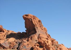
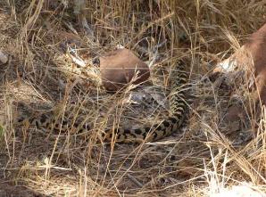
Many of the sandstone rock formations are
named such as Cobra Rock pictured above.
named such as Cobra Rock pictured above.
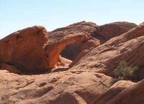
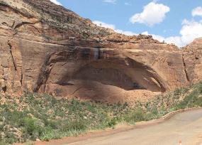
| Several natural arches have been formed as evidenced above. Recently, the largest arch in the park collapsed. |
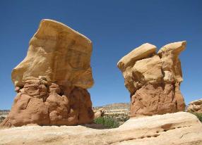
Four of the Seven Sisters are pictured above.
Red sandstone with a rich iron content
contrasts sharply with limestone
formations shown above.
contrasts sharply with limestone
formations shown above.
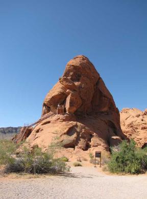
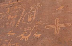
| We climbed the steep stairs of the Atlatl Rock shown left for outstanding examples of Indian rock art. The atlatl was a notched stick used to throw primitive spears and was the predecessor of the bow and arrow. |

| Prehistoric users of the Valley of Fire from ~300BC included the Basket Maker people and later the Anasazi Pueblo farmers. |
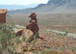
Balancing rocks and arches seemed to
abound in this rugged desert landscape.
abound in this rugged desert landscape.
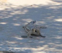
| We saw lots of lizards on our foray through the park including this guy who posed for us. |
A white-tailed antelope ground squirrel
lazed in some hard-to-find shade.
lazed in some hard-to-find shade.
| Fauna in the area included desert birds such as roadrunners and sage sparrow. There are many species of lizards and snakes as well as coyote, kit fox, skunk, jackrabbit and ground squirrels. The desert tortoise is present, but rare and is protected by state law. Flora is primarily several species of cacti, but also mallow, indigo bush and desert marigold. |
The most well-known of the park's formations:
Elephant Rock is also the park's logo.
Elephant Rock is also the park's logo.
We arrived in St. George, UT late in the
day with plans to visit Zion National Park
the next day. What to do with the evening?
Ah...America's national pasttime...baseball!
day with plans to visit Zion National Park
the next day. What to do with the evening?
Ah...America's national pasttime...baseball!
| Zion National Park is home to 67 species of mammals, 207 birds, 35 reptiles and amphibians, 9 fish and over 900 species of plants. |
| National monuments vs National Parks The two classes of reservations comprising the national-park and national-monument system differ primarily in the reasons for which they are established. National parks are areas set apart by Congress generally because of some outstanding scenic feature or natural phenomena. National monuments, on the other hand, are areas reserved by the National Government because they contain objects of historic, prehistoric or scientific interest and are usually established by presidential proclamation. |
| There are 392 areas in the US set aside as national parks, monuments, preserves, refuges and historic areas. Get more info from the National Park Service. |
| Zion National Park, Utah - 37N18.00 / 113W03.03 |
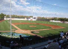

| The St. George Roadrunners' mascot Another bird for the Bird Sightings page? |
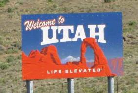
| We left Nevada behind, crossed a little corner of Arizona and finally we were in Utah. |

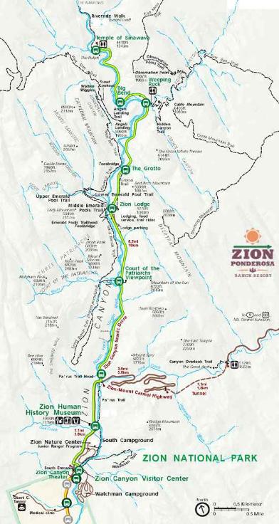
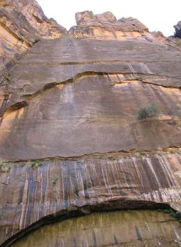
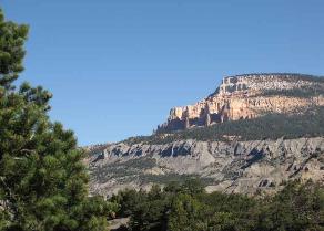
| Zion Canyon is about 10 miles long, its walls carved by the waters of the Virgin River. The first stop "Temple of Sinawava" (Paiute wolf god) offered a paved river walk along the banks of the Virgin in the narrowing canyon with walls of Navajo sandstone steeply rising all around us. |
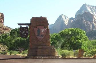
| Zion National Park The beauty of what is now Zion National Park was noted in a report by Leo A. Snow of St. George, Utah, following his 1908 survey of Zion Canyon for the U.S. Geological Survey. On July 31, 1909, President Taft created the Mukuntuweap National Monument by Presidential Proclamation, using the Paiute name for the canyon. Local pioneers called the area "Zion" and asked for a name change in 1918 when the monument was enlarged. By an act of Congress in 1919, it became Zion National Park and now contains about 147,000 acres of land. Why the name Zion? The term Zion has often been used as a metaphor for the Biblical land of Israel, any other Promised Land, or any other distant, but much wanted goal. A similar metaphoric transformation of the term "Zion" occurs in the Mormon religion . In this interpretation, Zion refers to a specific location to which members of the millennial church are to be gathered together to live. Issac Behunin, a Mormon settler living in the area in the 1860's, first used the name "Zion" for the canyon. He seemed to think that Zion was a "peaceful resting place" or "a heavenly place". We arrived at the park quite early and were lucky enough to get a parking place, but it was already crowded. During the summer months a free shuttle runs along the Zion Canyon Scenic Drive. Thank goodness, because there were so many cars and so much to see, it would have been near impassable on the narrow canyon road with all the traffic. We boarded the shuttle and went to the last stop first with the intention of stopping at all the others on the way back which we did. Each stop offered a special view or interesting rock formation or hike. Temps rose to 104F and we wilted in the midday sun. |
| Zion was in a word...fabulous. We've seen so many wonderful sights around the world, but it certainly didn't diminish the splendor and majesty of this park. One ranger called it the "WOW" factor and he was right. Eye candy at every turn of the head. We stayed in Cedar City for the night and left early the next morning for Cedar Breaks National Monument, not far away. The state offers five National Parks, seven National Monuments, two National Recreation Areas, a National Historic Site and six National Forests, |
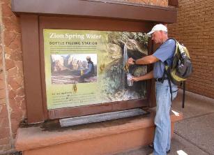
| We filled our water bottles with Zion spring water. |
| A gopher snake crossed out path. |
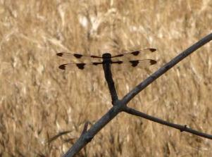
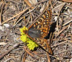
| Butterflies and dragonflies were abundant. |
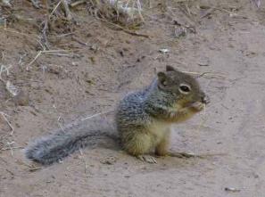
| Indifferent rock squirrels scurried along the trails. |
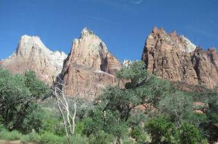
| The Great White Throne |
| The Patriarchs...Abraham, Issac and Jacob Peaks |
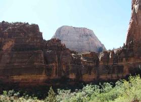
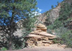
| Interesting formations were all around us. |
| Natural arch |
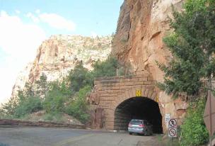
| Tunnel along the Zion-Mt Carmel Hwy |
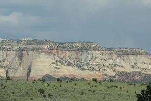
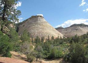
| Checkerboard Mesa - Eons of freezing and thawing created vertical cracks, while erosion by wind and rain accentuated the horizontal bedding planes of this distinctive petrified Navajo sandstone mountain so that over time a pattern of irregular crosshatches emerged, creating the checkerboard effect. |
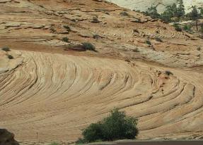
| Switchbacks, slickrock, buttes and spectacular views. We each had "cricks" in our necks from looking up, up, up. |
| Slickrock |
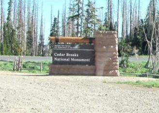
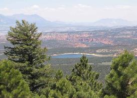
| Cedar Breaks National Monument, Utah - 37N64 / 107W95 |
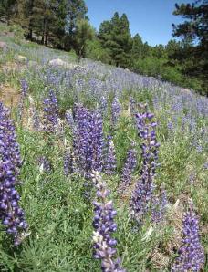
| The wildflowers were in bloom when we arrived at Cedar Breaks National Monument. The name originated from early settlers. "Cedar" for the cedar or juniper trees which grow here. "Breaks" is a term for badlands. This national monument was established in 1933. We celebrated our 26th anniversary here and enjoyed the cool 66F temps at 10,000'+ altitude. |
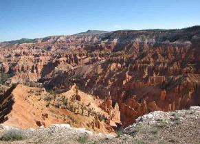
| A view of the amphitheater |

| The many wildflowers along the highways and byways along with the full bloom experienced at Cedar Breaks prompted a new web page just for Wildflowers of Western USA. Check it out. |
| Yet another spectacular vista |
| We were so high, there was still snow which David promptly fashioned into ammunition! |
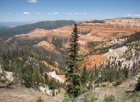
| A 5-mile scenic drive through the highcountry atop the Markagunt Plateau took us past the park's main attractions including overlooks, trailheads and the visitor center. We opted for an easy 2-mile walk along the Alpine Pond Trail. A beautiful 4-color brochure provided interpretive information as we walked along. |
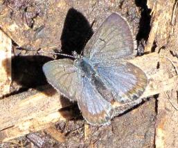
| The abundance of flowers led to an abundance of butterflies. Haven't gotten around to identifying butterfly species yet. Hmmm...food for thought. |
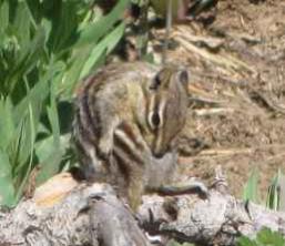
| Uintah chipmunk |
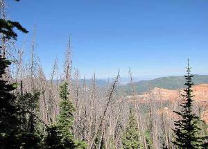
Dead trees were evidence of a bark beetle
epidemic in years past.
epidemic in years past.
| We particularly enjoyed this park as it was uncrowded and so very cool. We initially dug out our fleeces, but the midday sun and some exercise soon warmed us up. Walking along the trail, the smell of evergreen and pure mountain air was delightful. The only sounds were creaking of ancient bristlecone pine and the flutter of the quaking aspen leaves. Moths and butterflies flitted about, wildflowers were everywhere and the views were stupendous. We've found that each place we visit offers some unique feature that differentiates it from all the rest. It's our job to seek out that uniqueness and enjoy it to the fullest. |
| Red Canyon - Dixie National Forest, Utah - 40N93 / 109W39 |
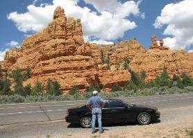
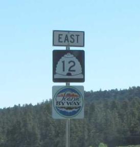
| We didn't have lots of time here, but Scenic Byway 12 led us directly through Red Canyon of the Dixie Forest. Part of Zion NP and the 2 million acre Dixie National Forest, it is only a few miles from Bryce Canyon NP as well. Red Canyon offered superb views and outstanding geological formations right from the car. Views are so spectacular, it nearly overwhelms your senses. |
| What's a hoodoo? Also called a tent rock, fairy chimney or earth pyramid, it's a tall, thin spire of rock that protrudes from the bottom of an arid drainage basin or badland. Hoodoos are comprised of soft sedimentary rock topped by harder, less easily-eroded stone that protects each column from the elements. |
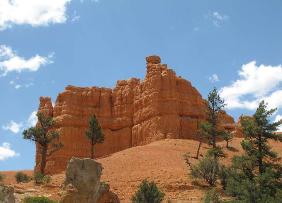
| Navajo sandstone rock formation...iron oxide content makes it red. |
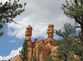
| Pinnacles, spires, hoodoos...wow! |
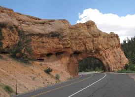
| As if the drive wasn't scenic and colorful enough, tunnels through the sandstone made it even more interesting. |
| Since we couldn't be in the tropics for our anniversary, we chose the little town of Tropic, UT for our 26th anniversary celebration. We splurged on a king suite for the night and had excellent fresh trout at nearby Clarke's Restaurant. Sorry...the rest of the evening was X-rated. |
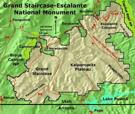
| Grand Staircase Escalante National Monument, Utah - 37N44 / 111W34 |
| We know...this is getting to be a bit much. So many national parks and monuments are in the area and it's hard to pass one up even if we don't have lots of time to explore each one thoroughly. Grand Staircase Escalante National Monument was once again "on the way" as we travelled along Scenic Byway 12. We saw more wildflowers in bloom along this stretch of Byway 12 than anywhere else in our travels.This made it a slow ride since I insisted that David stop to photograph each one. Patient man that he is, I managed to get lots of new photos...identifying them all is another story. |
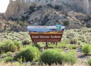
| Grand Staircase - Escalante National Monument is yet another geological marvel and was the last place in the continental US to be mapped. |
| Grand Staircase-Escalante National Monument spans nearly 1.9 million acres of America’s public lands. Since 2000, numerous dinosaur fossils over 75 million years old have been found here and thus the area is a virtual goldmine for geologists, paleontologists, naturalists, biologists and historians alike. Humans didn't settle permanently in the area until the late Basketmaker period, somewhere around AD 500. Both the Fremont and ancestral Puebloan people lived here. The Monument was declared in September 1996 by President Bill Clinton. |
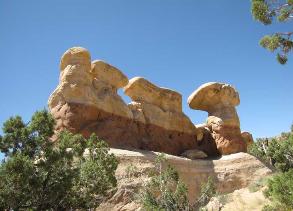
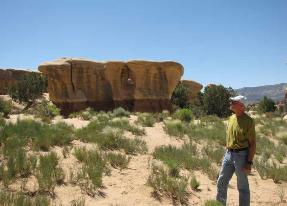
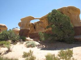
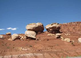
| We drove the unpaved Hole-in-the-Wall Road about 15 miles to Devil's Garden for an other-worldly display of hoodoos and rock formations. |
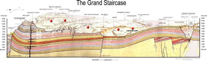
| The monument was named "Grand Staircase" because of its broad, tilted terraces which step up in great technicolor cliffs of vermilion, white, gray, pink and yellow. Together these escarpments expose 200 million years of the earth's history in a dramatic geologic rainbow of color. |
| Views are stupendous; wildflowers abound. This road was part of the Mormon Trail which led through the canyons. |
| Grand Staircase view |
| Natural arches were at every turn. |
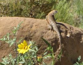
| A desert lizard poses in the hot sun. |
| Capitol Reef National Park, Utah - 38N17.29 / 111W15.45 |
| Established first as a National Monument in 1937 and later as a National Park in 1971, Capitol Reef comprises 378 square miles of colorful canyons, ridges, buttes, and monoliths. |
| What's in a name? The 65 million-year-old, hundred-mile-long warp in the earth's crust known as the Waterpocket Fold was once a formidable barrier to east-west travel. Early prospectors who had been sailors often called such an obstacle a "reef". The rounded sandstone formations bore a resemblance to the capitol domes, hence the name "Capitol Reef". |
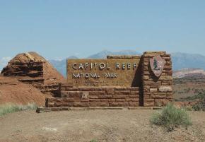
| This sign caught our attention. |
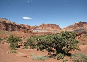
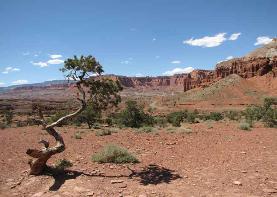
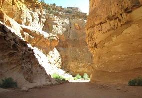
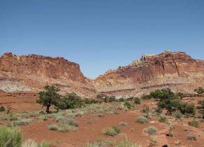
| Once again, the views were stupendous. We drove the scenic drive route to the Capitol Gorge Spur road...twisting, turning and wending its way through millenia-old sedimentary rock. Each turn was breathtaking and we came away with a new appreciation for rock formations! |
| Purple hills blooming lupine |
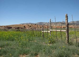
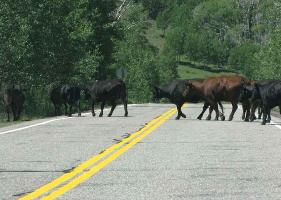
| Local traffic jam...this is free range territory. |
| Utah has 7 national monuments: Cedar Breaks, Natural Bridges, Dinosaur, Rainbow Bridge, Grand Staircase-Escalante, Timpanogos Cave and Hovenweep; 2 national recreation areas: Flaming Gorge and Glen Canyon; and 6 national forests: Ashley, Dixie, Fishlake, Manti-LaSal, Uinta, and Wasatch-Cache, plus 5 national parks. |
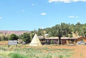
| The Flute Shop looked interesting and it was with lots of native American crafts! |
| Heading east, we finally joined up with I70, crossed the state line and found ourselves in familiar territory. Come home with us to the Rocky Mountain state of Colorado. |
Another option, but perhaps far less
exciting... Return to Home Page
exciting... Return to Home Page